
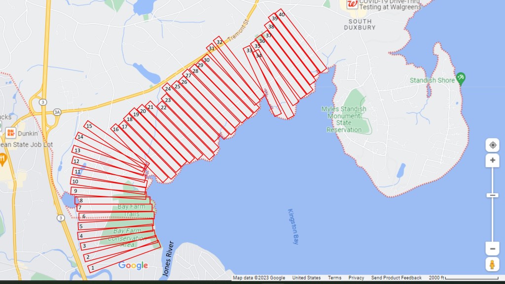
At around the same time as the 1627 Division of Cattle, the Plymouth Colony began the Second Division of Land. Each of the Purchasers was eligible to receive 20 acres per member of their family. For example, Single men would receive a single 20 acre lot, although a man with a wife and two children would receive an 80 acre lot.
The northern tracts were to begin at the Jones River and be five acres in width along the shore and four acres in depth from the shore. At this time, an acre of land was traditionally measured as 66 feet wide by 660 feet deep [43,560 square feet]. Thus, these twenty acre lots were to be as close to 330 feet wide by 2,640 feet [one-half mile] deep. As the shoreline is not straight, they would need to adjust the shapes of the lots to provide lots as close to the target 20 acres as possible while retaining a reasonable amount of frontage along Kingston Bay. It is also likely that the original surveyors of these lots also included some judgement as to the natural features of the land when adjusting the shape of lots in order to attempt to equalize the distribution of land [better topography may have been one feature they accounted for].
The map above is one conceptual approach to considering the distribution of approximately 800 acres of land to the west of Kingston Bay [as described for the process of the division of land in 1627]. Using these equal rectangular shapes, laid approximately next to one another along the shoreline, we can make a first approximation of the approximate location of where land would have been allocated to the firstcomers, based on information available as to relative position of neighbors. This can further be combined with what is known from analyzing the ancient deeds for lots in this vicinity along with eventual layout of streets over time. It must be remembered that the above map is simply a first approximation of relative location of where lots may have been laid out in the initial distribution [following the 20 acre methodology as provided in 1627]. The next step is to come up with the most likely order of the distribution of land (from south to north), combined with the number of shares which each Purchaser would be entitled, in order to approximate one possible location for each of the series of lots along Kingston Bay in the vicinity of Duxbury. The primary objective is to attempt to identify the approximate location (relative position) of the original grantees for the first approximately forty lots containing twenty acres – or approximately 800 acres [consisting of approximately 2.5 miles of shoreline to a depth of approximately 0.5 miles].
https://archive.org/details/cu31924082451455/page/n28/mode/1up

It is believed that the northern group of lots [numbers 33 thru 50] may have been allocated or reserved for Mr. William Collier. Collier was originally one of the Adventurers and possibly assisted in negotiating the deal between the Adventurers and the Purchasers in 1626, as it appears he exchanged his shares in Company stock for rights as a Purchaser. Collier did not move his family to Plymouth until June 1633, at which time his family consisted of himself, his wife, and their five daughters. In addition, Collier brought his apprentice (and future son-in-law) Job Cole and likely at least two additional men [one of them would have been Job Cole’s brother, John Cole, who died not long after their arrival]. In addition, Job Cole married one of William Collier’s daughters. Thus, it is reasonable to assume that between one and three of Mr. Collier’s lots may eventually have gone to Job Cole. William Collier’s men were taxed in 1633, prior to his arrival and settlement, so it is possible that this land may have been his Plymouth Colony estate being taxed at this time.
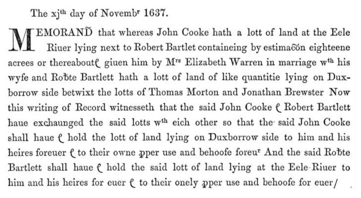
Robert Bartlett’s Original Grant of 20 acres
One example of identifying a Duxbury lot. The deed below, identifies that Robert Bartlett exchanged his single lot [estimated as eighteen acres or thereabout] which was located in Duxbury with John Cooke. Said Duxbury lot was located between the lots of Thomas Morton and Jonathan Brewster. The Division of Cattle list identifies that Robert Bartlett was number 12 in company 10 and due a single share – so he would have also been due a single 20 acre share of land. Further we can identify that Jonathan Brewster and his family were numbers 6 thru 9 in company 5 and were due four shares [80 acres] and that Thomas Morton was not named in the Division of Cattle [suggesting he obtained his Duxbury land through transfer of some sort].
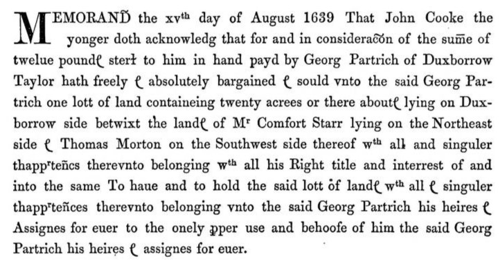
Further, John Cooke sold this lot to George Partridge. This deed identifies the 20 acres as being between Comfort Starr and Thomas Morton.
Thus, we can identify that Robert Bartlett received 20 acres [original grant as a Purchaser], transferred it to John Cooke in November 1637 and then John Cooke transferred it to George Partridge in August 1639. When Cooke acquired the property it was described as being between lands of Jonathan Brewster and Thomas Morton. When Partridge acquired the property it was described as being between lands of Comfort Starr and Thomas Morton. This can be explained by the deed in which Jonathan Brewster sold his 80 acre lot to Comfort Starr.
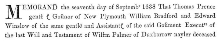
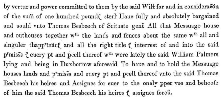
William Palmer’s Original Grant of 60 acres
The Duxbury land originally granted to William Palmer was sold during the probate on his estate to Thomas Besbeech. William Palmer would have likely been granted 60 acres as members 8 thru 10 of company 7. This information helps us in seeking the location by looking for other clues based on the subsequent owner [Thomas Besbeech] combined with the suspected size of the lot [60 acres].
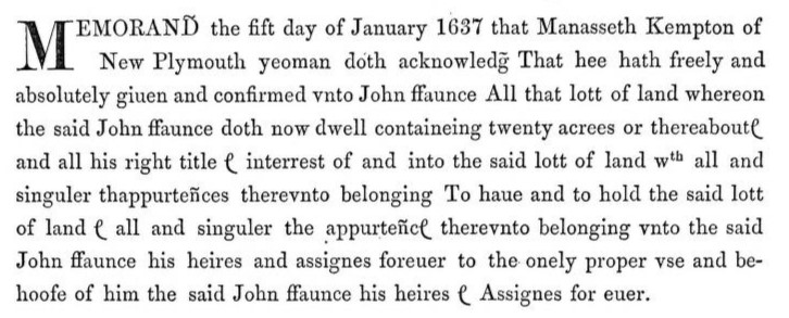
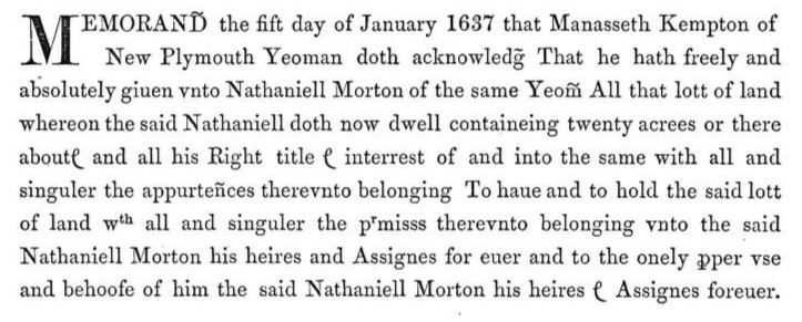
Manasseth Kempton’s original grant of 40 acres
Manasseth Kempton transferred 20 acres to John Faunce and 20 acres to Nathaniel Morton in January 1637. Manasseth Kempton and Julian Kempton were members 8 and 9 of the 11th company and eligible to have received two 20 acre lots in the 1627/8 Division of Land. Thus, the 20 acres transferred to John Faunce and 20 acres transferred to Nathaniel Morton would have been adjacent to one another.
Jonathan Brewster’s original 80 acre grant of land
Jonathan Brewster sold 80 acres to Comfort Starr

